


aldergrove provincial park

deka
User
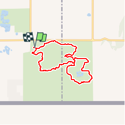

Length
7 km

Max alt
103 m

Uphill gradient
111 m
Km-Effort
8.5 km

Min alt
57 m

Downhill gradient
112 m
Boucle
Yes
Creation date :
2017-06-06 00:00:00.0
Updated on :
2017-06-06 00:00:00.0
1h56
Difficulty : Easy

FREE GPS app for hiking
 SityTrail
IGN / Geographical institutes
SityTrail World
The world is yours!
About
Trail Walking of 7 km to be discovered at British Columbia, Unknown, Township of Langley. This trail is proposed by deka.
Description
départ du premier parking.
Positioning
Country:
Canada
Region :
British Columbia
Department/Province :
Unknown
Municipality :
Township of Langley
Location:
Unknown
Start:(Dec)
Start:(UTM)
538833 ; 5429261 (10U) N.
Comments
Trails nearby